
Revolutionary Cycling on the C&D Canal Path
Chesapeake City, Maryland to Delaware City, Delaware
C&D Canal Path
Distance: 14 Miles
At first glance, the C&D Canal Path looks like a simple, flat ribbon of pavement running along a working shipping channel. Spend some time on it, though, and the appeal becomes clear: steady miles beside a historic canal, long open views across water and farmland, and the chance to finish in Delaware City, a small town with Revolutionary-era roots. What begins as a utility corridor ends as a ride with more history and scenery than you might expect.
The trail stretches about 14 miles between Chesapeake City, Maryland, and Delaware City, Delaware.
Flat, smooth and paved all the way
The path follows the north bank of the Chesapeake & Delaware Canal, a working waterway still used by cargo ships and barges. The canal is wide, and the path is paved asphalt broad enough for two-way use by cyclists, walkers, and runners. This Delaware bike trail is flat for the entire length, making it a moderately long, level ride in the Mid-Atlantic.
Near St. Georges, the first thing you notice are the canal bridges overhead. The St. Georges Bridge and the newer Senator William V. Roth Jr. Bridge rise high above the water, reminders that this is both a recreation corridor and an industrial passage. Ships move slowly along the canal, and riders often pause to watch them pass. The wide expanse of water beside the trail creates views stretching to fields and woodlots on the opposite bank.
The pavement is smooth and well-maintained. Trailheads have parking, and some have restrooms. Between St. Georges and Delaware City, the surroundings are quiet, broken by the sound of waterfowl and the distant rumble of engines from ships or trucks on nearby roads. Shade is sparse, and in summer the sun can be intense, reflecting off pavement and water. Wind is another factor—headwinds along the canal can feel constant.
Plenty of services, a few drawbacks
Services are clustered at the endpoints. Delaware City, at the eastern end, dates back to the early 19th century, with a compact downtown that includes restaurants, ice cream shops, and small stores. Fort Delaware State Park is just across the river on Pea Patch Island, accessible by ferry, and adds a historical feeling. At the western end, Chesapeake City has cafés, bed-and-breakfasts, and a marina, just beyond the Delaware border.
Drawbacks of the trail include its exposure to the elements and limited variation in scenery. The straight, flat corridor can feel repetitive, and without tree cover, the quality of the ride depends heavily on weather. Strong sun, headwinds, or sudden storms have full effect here. Wildlife adds some interest—osprey and herons are common—but otherwise the experience is about water, sky, and pavement. For some riders, that simplicity is the appeal; for others, it can feel monotonous.
The path’s accessibility makes it popular, and weekends can bring steady use, especially around trailheads. The width accommodates passing, but cyclists need to be patient with joggers, walkers, and families on bikes. Even so, crowding rarely reaches the level seen on urban trails.
Pick your season
Cycling in Delaware means spring and fall are good times to ride, when temperatures are milder and winds lighter. Summer requires planning—start early to avoid midday heat. Winter brings fewer users, but icy spots can linger in shaded cuts near bridges.
The C&D Canal Path runs as a level, paved line much of the way, framed by wide water views and a working canal. The trail’s plain first impression gives way to a distinctive experience: steady miles along a historic shipping route, a finish in a small town with deep history, and the chance to see giant ships sliding silently past. It’s a corridor where industry and recreation share space, and that mix is what makes it stand out among trail rides.
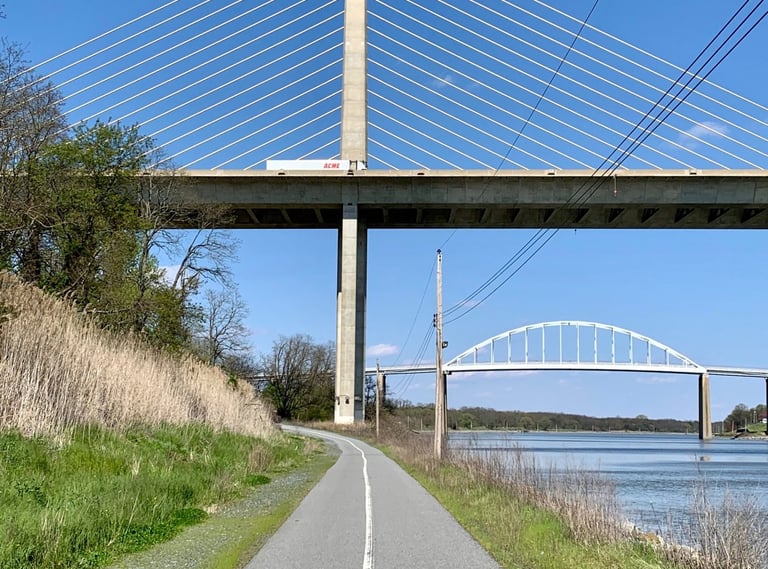

Cycling the C&D Canal Path Photo: Delaware Greenways


Skullduggery on the bike! Lead the pack with this jersey.
C&D Canal Path
Distance: 14 Miles
At first glance, the C&D Canal Path looks like a simple, flat ribbon of pavement running along a working shipping channel. Spend some time on it, though, and the appeal becomes clear: steady miles beside a historic canal, long open views across water and farmland, and the chance to finish in Delaware City, a small town with Revolutionary-era roots. What begins as a utility corridor ends as a ride with more history and scenery than you might expect.
The trail stretches about 14 miles between Chesapeake City, Maryland, and Delaware City, Delaware.
Flat, smooth and paved all the way
The path follows the north bank of the Chesapeake & Delaware Canal, a working waterway still used by cargo ships and barges. The canal is wide, and the path is paved asphalt broad enough for two-way use by cyclists, walkers, and runners. This Delaware bike trail is flat for the entire length, making it a moderately long, level ride in the Mid-Atlantic.
Near St. Georges, the first thing you notice are the canal bridges overhead. The St. Georges Bridge and the newer Senator William V. Roth Jr. Bridge rise high above the water, reminders that this is both a recreation corridor and an industrial passage. Ships move slowly along the canal, and riders often pause to watch them pass. The wide expanse of water beside the trail creates views stretching to fields and woodlots on the opposite bank.
The pavement is smooth and well-maintained. Trailheads have parking, and some have restrooms. Between St. Georges and Delaware City, the surroundings are quiet, broken by the sound of waterfowl and the distant rumble of engines from ships or trucks on nearby roads. Shade is sparse, and in summer the sun can be intense, reflecting off pavement and water. Wind is another factor—headwinds along the canal can feel constant.
Plenty of services, a few drawbacks
Services are clustered at the endpoints. Delaware City, at the eastern end, dates back to the early 19th century, with a compact downtown that includes restaurants, ice cream shops, and small stores. Fort Delaware State Park is just across the river on Pea Patch Island, accessible by ferry, and adds a historical feeling. At the western end, Chesapeake City has cafés, bed-and-breakfasts, and a marina, just beyond the Delaware border.
Drawbacks of the trail include its exposure to the elements and limited variation in scenery. The straight, flat corridor can feel repetitive, and without tree cover, the quality of the ride depends heavily on weather. Strong sun, headwinds, or sudden storms have full effect here. Wildlife adds some interest—osprey and herons are common—but otherwise the experience is about water, sky, and pavement. For some riders, that simplicity is the appeal; for others, it can feel monotonous.
The path’s accessibility makes it popular, and weekends can bring steady use, especially around trailheads. The width accommodates passing, but cyclists need to be patient with joggers, walkers, and families on bikes. Even so, crowding rarely reaches the level seen on urban trails.
Pick your season
Cycling in Delaware means spring and fall are good times to ride, when temperatures are milder and winds lighter. Summer requires planning—start early to avoid midday heat. Winter brings fewer users, but icy spots can linger in shaded cuts near bridges.
The C&D Canal Path runs as a level, paved line much of the way, framed by wide water views and a working canal. The trail’s plain first impression gives way to a distinctive experience: steady miles along a historic shipping route, a finish in a small town with deep history, and the chance to see giant ships sliding silently past. It’s a corridor where industry and recreation share space, and that mix is what makes it stand out among trail rides.
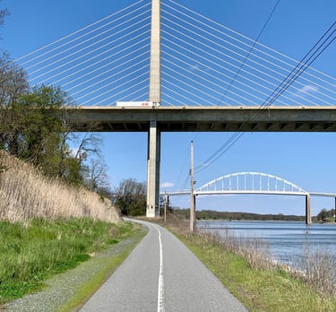
Cycling the C&D Canal Path Photo: Delaware Greenways

Skullduggery on the bike! Lead the pack with this jersey.
Some pages contain affiliate links. If you purchase something through one of these links, we may earn a small commission.