
Urban Bustle to Prairie Calm on the Grand Illinois Trail
Chicago
Grand Illinois Trail
Distance: 535 miles
Ride With GPS Map (Includes Segment Routes)
The Grand Illinois Trail runs 535 miles through northern Illinois, forming a vast loop from Lake Michigan west to the Mississippi River and back across the state along the Illinois River valley. It’s a route that ties together city, countryside, and canal, blending paved paths, quiet country roads, and stretches of limestone rail-trail.
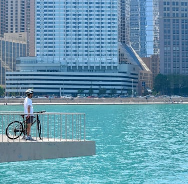
The trail for many riders begins along the lakefront north of Chicago, where the city’s skyline fades into open shoreline. Early miles follow the paved paths through suburban parkways before easing into rural farmland. The transition from urban bustle to open prairie happens gradually — one moment you’re tracing the shoreline beneath high-rises, and a few hours later, you’re surrounded by open fields, grain silos, and the quiet rhythm of Midwest backroads.
Crossing rivers into the past
Heading west, the route crosses rivers and low ridges before meeting the Hennepin Canal and its historic towpath, a highlight of the ride. Here the surface changes to crushed limestone. Bridges, locks, and stone walls recall the region’s industrial past, while herons and egrets glide low over the water. Small towns like Sheffield, Geneseo, and Rock Falls are places to stop, each with diners and motels that feel unchanged from decades past.
Beyond Rock Falls, the trail bends south along the Mississippi River and then east through the Illinois River valley. The landscape becomes greener and hillier, the flat farmland giving way to river bluffs and wooded stretches. Near Starved Rock and Ottawa, sandstone cliffs rise above the water, and long wooden bridges carry the trail across slow-moving streams. East of LaSalle, the path quiets again into open country, dotted with red barns and cornfields that run to the horizon.
Services are reliable around the urban and suburban edges, but once you reach the central corridor the miles between towns can feel long. It’s best to plan water and food stops carefully, especially on the western side of the loop. Some road segments have narrow shoulders, and in wet weather, sections of limestone can become soft or rutted. Still, maintenance is steady, and wayfinding is easy thanks to well-marked cues and maps from the state cycling program.
Riding through the seasons
Spring and fall bring the best riding — cool air, bright color, and fewer bugs. Summer offers long daylight hours but early starts are best, with plenty of hydration. In autumn, the ride along the Illinois River glows with orange and gold leaves, and morning fog often hangs low over the water.
From Lake Michigan’s shoreline through prairies, canal towns, and river valleys, the Grand Illinois Trail links the diversity of an entire state. It’s a ride that moves from noise to quiet, from industry to open space — a reminder of how connected the Midwest’s landscapes really are.


Warm hands on a cold ride - get these best-selling gloves
A rider takes in the Chicago skyline. An Illinois bike trail that passes from urban to rural.
Ride the region - Missouri's Katy Trail
Grand Illinois Trail
Distance: 535 miles
Ride With GPS Map (Includes Segment Routes)
The Grand Illinois Trail runs 535 miles through northern Illinois, forming a vast loop from Lake Michigan west to the Mississippi River and back across the state along the Illinois River valley. It’s a route that ties together city, countryside, and canal, blending paved paths, quiet country roads, and stretches of limestone rail-trail.
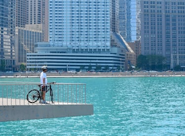
The trail for many riders begins along the lakefront north of Chicago, where the city’s skyline fades into open shoreline. Early miles follow the paved paths through suburban parkways before easing into rural farmland. The transition from urban bustle to open prairie happens gradually — one moment you’re tracing the shoreline beneath high-rises, and a few hours later, you’re surrounded by open fields, grain silos, and the quiet rhythm of Midwest backroads.
Crossing rivers into the past
Heading west, the route crosses rivers and low ridges before meeting the Hennepin Canal and its historic towpath, a highlight of the ride. Here the surface changes to crushed limestone. Bridges, locks, and stone walls recall the region’s industrial past, while herons and egrets glide low over the water. Small towns like Sheffield, Geneseo, and Rock Falls are places to stop, each with diners and motels that feel unchanged from decades past.
Beyond Rock Falls, the trail bends south along the Mississippi River and then east through the Illinois River valley. The landscape becomes greener and hillier, the flat farmland giving way to river bluffs and wooded stretches. Near Starved Rock and Ottawa, sandstone cliffs rise above the water, and long wooden bridges carry the trail across slow-moving streams. East of LaSalle, the path quiets again into open country, dotted with red barns and cornfields that run to the horizon.
Services are reliable around the urban and suburban edges, but once you reach the central corridor the miles between towns can feel long. It’s best to plan water and food stops carefully, especially on the western side of the loop. Some road segments have narrow shoulders, and in wet weather, sections of limestone can become soft or rutted. Still, maintenance is steady, and wayfinding is easy thanks to well-marked cues and maps from the state cycling program.
Riding through the seasons
Spring and fall bring the best riding — cool air, bright color, and fewer bugs. Summer offers long daylight hours but early starts are best, with plenty of hydration. In autumn, the ride along the Illinois River glows with orange and gold leaves, and morning fog often hangs low over the water.
From Lake Michigan’s shoreline through prairies, canal towns, and river valleys, the Grand Illinois Trail links the diversity of an entire state. It’s a ride that moves from noise to quiet, from industry to open space — a reminder of how connected the Midwest’s landscapes really are.
Warm hands on a cold ride - get these best-selling gloves
A rider takes in the Chicago skyline. An Illinois bike trail that passes from urban to rural.
Ride the region - Missouri's Katy Trail
Some pages contain affiliate links. If you purchase something through one of these links, we may earn a small commission.